
Full list of Spatial Science resources at:
https://github.com/pnphannisa/awesome-thai-gis
Thailand’s Tessaban (municipality equivalent) lat lon, and province lat lon including basic economic and social data at:
https://github.com/pnphannisa/thailand_spatial_resources
“Spatial Science is the study of spatial information describing the Earth, its physical features and the built environment. It incorporates fields such as geographic information systems (GIS), global positioning system (GPS), remote sensing, surveying, and cartography. With its rapid advancement, spatial technology is now part of our daily lives, ranging from personal GPS navigation devices to the sophisticated system for air-traffic control”(Stephen F. Austin State University, 2018).
For me, Spatial Science is an expanded horizon of ‘Data Science’ as they are both focused on solving problems in a scientific and evidence-based manner, while Spatial Science emphasizes the location-based aspect of it. Please read How to Add Data Science to your GIS Skills.
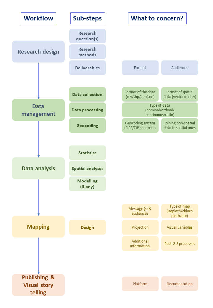
Purposes of this post: to recommend work cycle and essential resources of spatial science. The structure of this article is divided into 5 parts as the following.
- Basic knowledge – very basic concept of Spatial Science, common workflow, and software used in the processes
- Data preparation – good result comes from good data. Data preparation is an essential early process of Spatial Science which involves data collection, data processing, and geocoding (to make non-spatial data become spatial).
- Statistics – If someone does data/spatial science without some knowledge in statistics, they are bulls****.
- Geography & Geovisualization – spatial science can’t be spatial without geography
- Spatial Science & Beyond – new techs that involve Spatial Science. Big data, machine learning, AI, all your favorite buzzwords.

Basic knowledge
- What is GIS? Geographic Information System (GIS) is
is a system designed to capture, store, manipulate, analyze, manage, and present spatial or geographic data. GIS applications are tools that allow users to create interactive queries (user-created searches), analyze spatial information, edit data in maps, and present the results of all these operations (Wikipedia, 2019). Please read more at (Principles of Geographic Information System) - Applications of GIS GIS has been adopted by various fields of professions, from hazard management to data journalism, as an essential part of works. Please see (67 Important GIS Applications and Uses)
- GIS software There is more than 50 GIS software available in the market, both open source and proprietary. The most familiar ones are ArcGIS (proprietary) and QGIS (open source).
- ArcGIS and QGIS: ฺBoth are the most recognized GIS programs in the market. IMO, QGIS is free while ArcGIS (expensive) is better in terms of advanced performance.
- Time needed to master Spatial Science 101, including learning to use GIS software: at least 1 semester or 6 months (it will take some time to understand the whole process and be able to deliver the first small project).

Top GIS software
Data preparation
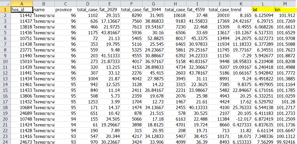
- Common file types used in Spatial Science: during Spatial Science processes, you will deal with three major file types: 1. (non-spatial) CSV, XLS, JSON; 2. (spatial, vector) SHP, GEOJESON, KML; and 3. (spatial, raster) JPG, TIFF.
- (Non-spatial data)
- Data types in statistics: understanding data types: nominal, ordinal, interval, and ratio; is crucial to data collection, data processing, statistical analysis, and visualization. Please read (Data Types in Statistics)
- Common file type – CSV: A lot of data used in Spatial Science is stored in Comma Separated Value (CSV) file type which is a delimited text file that uses a comma to separate values (Wikepedia, 2019). CSV, compared to Microsoft Excel’s XLS, is smaller and more versatile across different platforms but can contain less complex data. Please read (What is CSV file?) (CSV vs XLS)
- Common file type – JSON (Java Script Object Notation): Another common file type used to store data. Compared to CSV, it is less compact, but be able to store hierarchical data. Also, it is more versatile, can be used for programming languages. Please read (JSON vs CSV).
- (Spatial Data)
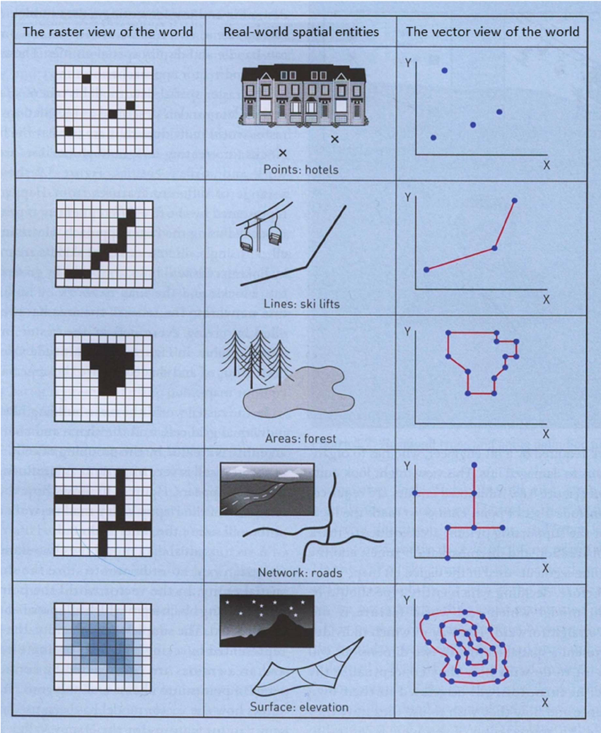
- Vector and Raster: in GIS, vector and raster are two different ways of representing spatial data, vector, and raster. Raster data is made up of pixels (or cells), and each pixel has an associated value. Vector data consists of individual points, which (for 2D data) are stored as pairs of (x, y) co-ordinates (GIS Stack Exchange, 2017) (Intro to GIS and GIS Vector and Raster Data Models).
- Vector data is smaller and able to contain multiple attributes. It is suitable for representing discrete features with definable boundaries. In contrast, Raster data, can only contain a single attribute, is suitable for representing continuous spatial features.
- Spatial data filetype: please read (The Ultimate List of GIS Formats – Geospatial File Extensions)
- Common file type (vector) – SHP: The most common geospatial file type, mainly used in ArcGIS (the most common GIS software) but other proprietary and open source platforms also accept SHP files.
- Common file type (vector) – GEOJSON: mostly used for web-based mapping.
- Common file type (vector) – KML/KMZ (Keyhole Markup Language): XML based file, mainly used for Google Earth
- Common file types for raster data: raster data is basically contained in graphic file type such as JPEG and TIFF.
- Data cleaning and transformation
- Conversion between non-spatial data types
- Conversion between vector and raster
- Data loss between conversion
- Data governance is a data management concept concerning the capability that enables an organization to ensure that high data quality exists throughout the complete lifecycle of the data. The key focus areas of data governance include availability, usability, consistency (Wikipedia, 2019). Key concerns are but not limited to:
- Consistent data (variable names, units, and formats)
- Documentation of data collection methods
- Reproductibility of data
Statistics
- GIS analyses heavily rely on statistics such as but not limited to:
- Descriptive Statistics
- Inferential Statistics: Confidence Intervals, Hypothesis Testing, and Sampling
- Spatial pattern: classification, regression, clustering
- Interpolation
- I recommend spending some times with the basics of statistics.

Geography & Geovisualization
- Mapping (aka cartography) is an essential part of Spatial Science. As we do analyses on maps and we deliver results on maps, learning about basic geography especially how maps are made is a must.
- (An Open Geospatial Textbook of the Nature of Geographic Information by Penn State University)
- The open textbook covers basic geography you need to know such as:
- How to reference points on earth: Geographic coordinate system
- How to transform those points on a map (3D -> 2D): projection and projected coordinate system
- How to collect earth data: satellite imagery, remote sensing, land surveying, GPS
- Other essential parts of a map: scales
- How to combine geographic data with social data: TIGER, Census Bureau, and Geocoding technique
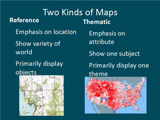
- Types of Maps Reference Map vs Thematic Map: Reference Map tells locations and objects (mainly for reference). Thematic Map tells story (ies). As Spatial Science focuses on solving location-based problems in a scientific and evidence-based manner, we encounter and deal with thematic maps more often than the former one. Major thematic map types are:
- Univariate Choropleth (represent one numerical data by one color scheme)
- Bivariate Choropleth (represent two numerical data by two color schemes)
- Univariate Proportional Symbol (represent one numerical data by size of symbol)
- Bivariate Proportional Symbol (represent two numerical data by size and color of symbol)
- Dot Density
- Non Contiguous Cartogram
- Bivariate non contiguous Cartogram
- Isopleth
- Chernoff Face
- And some basics of graphic design such as:
- Design fundamental (composition, color theory)
- Typography
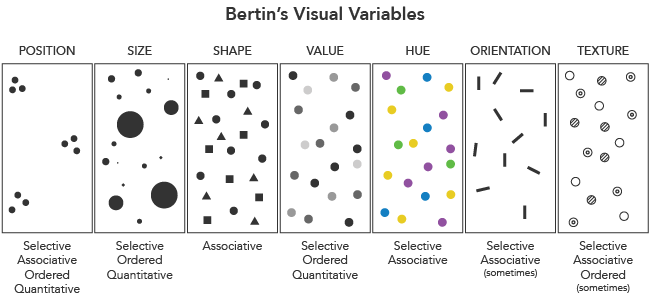
- Visual variables
- Types of maps: Reference Map and Thematic Map
- Visualization platforms
- Ethics in cartography
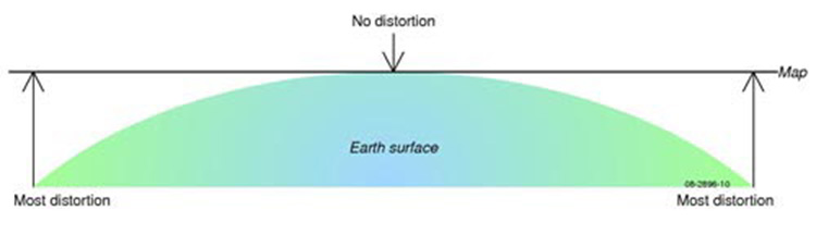
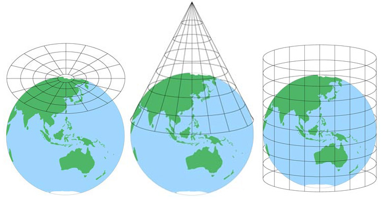
MAP PROJECTIONS: WHY THE SAME WORLD LOOKS DIFFERENT)

Visual Story Telling
- Formats and platforms
- Resources
Spatial Science & Beyond
- Data scraping
- ‘Big Data’: not all databases are automatically called ‘big data’, read (How Big is Big Data?)
- Coding and Spatial Science
- AI and Spatial Science: see an example of State-of-the-Art Satellite Image Classification with Deep Learning

